

By Pamela Cruz. Peninsula 360 Press [P360P].
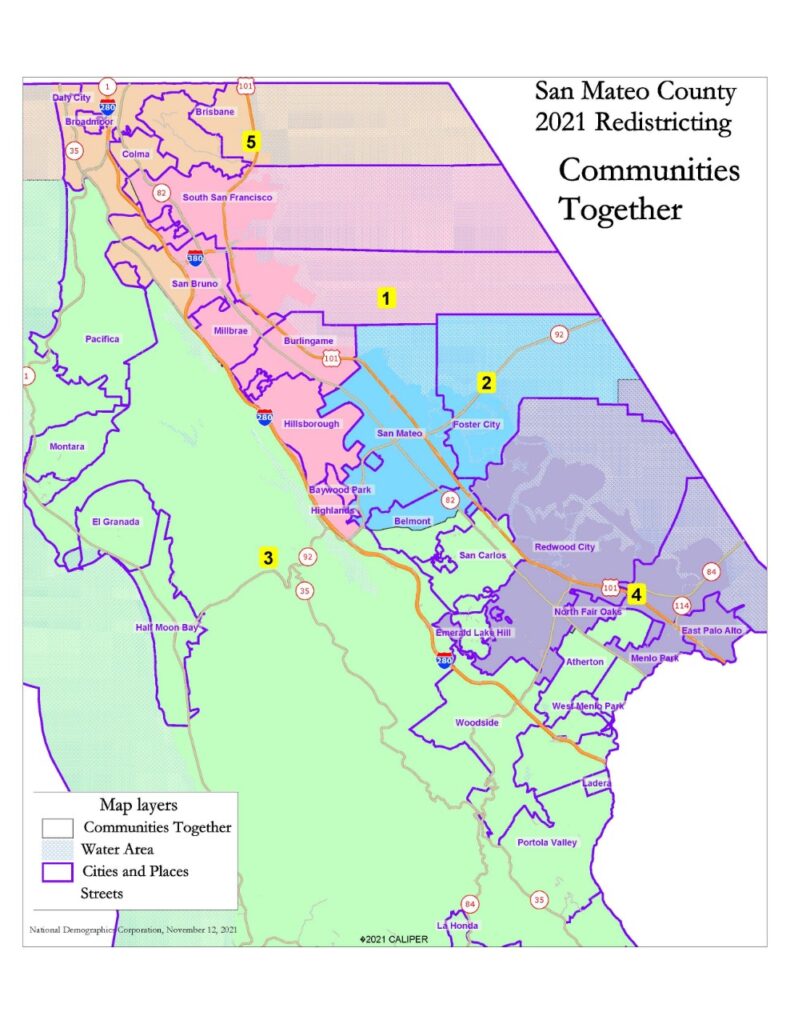
The San Mateo County Board of Supervisors voted "unanimously" Tuesday to adopt the "Communities United" map that sets district lines for the next decade.
"The 5-0 vote culminates a months-long process of public engagement and outreach," the board detailed in a statement.
The Board, by state law, must adopt a new map establishing boundaries for each of the five supervisorial districts by December 15, 2021, for use in the June 2022 primary.
"This is truly a historic occasion for everyone who cares about fair maps, who cares about making sure everyone has a seat at the table," said David J. Canepa, chairman of the Board of Supervisors.
"The Communities United map establishes district boundaries that respect and empower the diverse communities in our county," he added.
For his part, San Mateo County Supervisor Don Horsley thanked those involved in making the decision and those who, he said, went out of their way to participate and provide input.
"Making sure we have districts that minimize divisions and empower local communities is the very essence of representative democracy," he stressed.
The Board's task was to create five districts to reflect the population changes according to the 2020 federal Census. This means that each district must include approximately 153,083 residents, so that each person has equal representation.
It should be noted that the location of the district lines will determine which voters can vote for which candidate.
The population is shown below on the approved map:
| COMMUNITIES TOGETHER: TOTAL POPULATION |
| District | 1 | 2 | 3 | 4 | 5 | Total |
| Total pop. | 147,541 | 158,4809 | 153,827 | 153,790 | 151,779 | 765,417 |
| Deviation from the ideal | -5,542 | 5.397 | 744 | 707 | -1,304 | 10,939 |
| Each of the five districts should contain about 153,083 people. |
Thus, according to the new map, two of the five new districts, District 1 and District 5, have voting age populations that are majority minority, meaning that the majority of eligible voters are racial or ethnic minorities.
Specifically, District 1 is 58 percent majority-minority and District 5 is 80 percent majority-minority.
In addition, Districts 2 and 4 have roughly equal voting age populations of Caucasian minority and non-Hispanic residents.
"Four of the five districts provide significant opportunities for traditionally underrepresented groups to elect candidates who reflect the values of their communities," Canepa said. "This is a significant achievement in drawing lines that respect the makeup of our communities today."
With the approved map, this will be the voting age citizen population:
| COMMUNITIES TOGETHER: VOTING-AGE CITIZEN POPULATION |
| District | 1 | 2 | 3 | 4 | 5 | Total |
| Total | 99,909 | 96.306 | 111,071 | 87,214 | 106,347 | 500,848 |
| Hispanic | 21% | 14% | 10% | 28% | 18% | 18% |
| Caucasians | 42% | 52% | 72% | 50% | 20% | 47% |
| African Americans | 2% | 3% | 2% | 6% | 4% | 3% |
| Asian / Pacific Islander | 35% | 30% | 15% | 15% | 57% | 31% |
Horsley said the new districts also respect the geographic integrity of local communities and neighborhoods with shared interests, known as "communities of interest."
He said the new map, for example, minimizes the divide between coastal communities and those living in East Palo Alto, Belle Haven, North Fair Oaks and Redwood City.
While the five districts must have a substantially balanced population, the requirements also include meeting equal federal and state voting rights and the following state law criteria ordered by rank:
- Draw districts that are, to the extent possible, geographically contiguous.
- Keep communities and cities of interest intact, as much as possible.
- Have easily identifiable boundaries - main roads, railroads, streets, rivers, mountains - as far as possible.
- Draw districts to encourage geographic compactness, to the extent possible.
The release also notes that, to assist in the redistricting process, the Board earlier this year appointed an advisory commission, called the 2021 District Oversight Lines Advisory Commission, whose 15 members were recommended by members of local chapters of the League of Women Voters.
Although the federal census data was delayed, the Commission initiated a series of 10 public meetings to receive public testimony, discuss communities of interest and review draft maps. The Commission ultimately voted on Oct. 28, 2021, to recommend two maps to the Board of Supervisors by a vote of 8-7, the document detailed.
The Board, at a public meeting on November 16, 2021, directed staff to return on December 7, 2021 with an ordinance adopting the "Communities United" map.
This map "best meets the requirements of federal and state law, including, to the extent possible, respecting the geographic integrity of any neighborhood or local community of interest," according to the attached staff report.
The Board today approved an ordinance adopting the map, a measure that must come before the Board for a second reading on December 14, 2021.
While the new map will determine the lines for the next decade, four of the five current members of the Board of Supervisors are barred from running for re-election due to term limits.
You may be interested in: Louisiana residents in uncertainty over redistricting
