

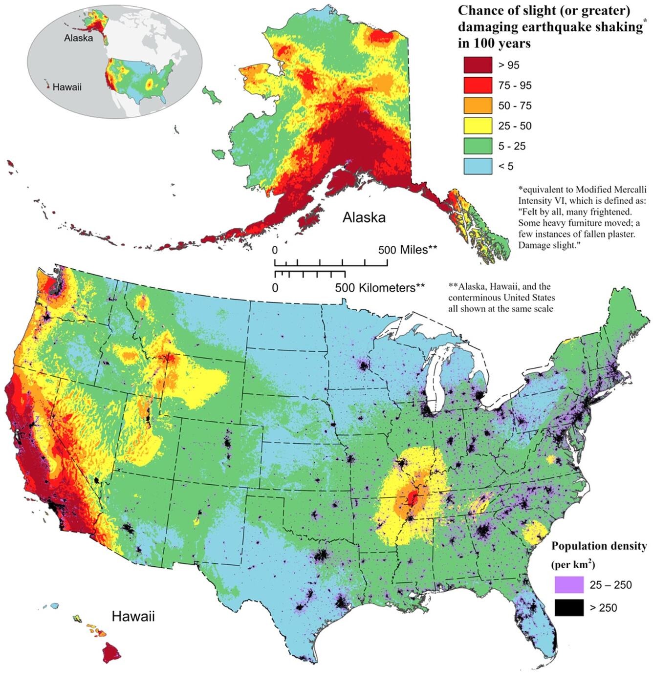
Much of California, Alaska and Hawaii have a greater than 95 percent chance of experiencing a large earthquake in the next 100 years, according to a new map from the United States Geological Survey (USGS, for its acronym in English).
This was one of several key findings from the latest National Seismic Hazard Model (NSHM) by a team of more than 50 USGS scientists and engineers, which also says nearly 75 percent of the United States could experience damaging earthquakes and intense tremors. soil, putting hundreds of millions of people at risk.
The model was used to create a color-coded map that pinpoints where damaging earthquakes are most likely to occur based on insights from seismic surveys, historical geological data, and the latest data collection technologies.
The NSHM update requested by Congress was created as an essential tool to help engineers and others mitigate how earthquakes impact the most vulnerable communities by showing the likely locations of earthquakes and the magnitude of shaking they could produce .
New tools and technology identified nearly 500 additional faults that could produce a damaging earthquake, showing the evolving landscape of earthquake research.
“This was a massive, multi-year collaborative effort between federal, state and local governments and the private sector,” said Mark Petersen, USGS geophysicist and lead author of the study. “The new seismic risk model represents a fundamental achievement to improve public safety.”
The latest version, the first comprehensive 50-state assessment, was updated from earlier versions published in 2018 (U.S.), 2007 (Alaska), and 1998 (Hawaii).
The notable changes in the new model show the potential for more damaging earthquakes along the central and northeastern Atlantic coastal corridor, including the cities of Washington DC, Philadelphia, New York and Boston.
In addition, it specifies that there is the possibility of greater shaking in the seismically active regions of California and Alaska.
In that sense, the new model also characterizes Hawaii as a country with a greater potential to suffer tremors due to observations of recent volcanic eruptions and seismic disturbances on the islands.
“Earthquakes are difficult to forecast, but we have made great progress with this new model,” Petersen said. “The update includes more faults, better characterized land surfaces, and computational advances in modeling that provide the most detailed view ever seen of the earthquake risks we face.”
You may be interested in: Avalanche in Tahoe, California, leaves one dead, one injured and 4 buried under snow
