

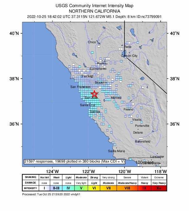
A magnitude 5.1 earthquake with an epicenter east of San Jose, recorded around noon Tuesday, was felt across much of the Bay Area and caused some traffic delays, but no major damage has been reported.
According to the US Geological Survey ?USGS, for its acronym in English?, the quake occurred at 11:42 a.m. and had its epicenter about 12 miles east of San Jose.
The USGS initially said the quake had a magnitude of 5.0, however they later upgraded it to 5.1. An aftershock of magnitude 2.9 also occurred in the same place about five minutes later, while the last aftershock was recorded at 5:08 p.m. with a magnitude of 3.6 in the same epicenter.
The 5.1 quake is the largest in the Bay Area since a 6.0 quake recorded in the Napa area. Residents of the region reported through social networks that they felt the shock on Tuesday. In turn, it was the largest earthquake on the northern end of the central segment of the Calaveras Fault since a magnitude 5.4 earthquake in 2007.
Many people also received advanced notification seconds before the movement occurred via the MyShake smartphone app developed at the University of California at Berkeley, according to the Governor's Office of Emergency Services.
BART officials held the trains so crews could inspect the tracks for possible damage, but cleared all service for normal operations around 12:20 p.m.
Glitch Skulls
According to the USGS, the total slip rate on the Calaveras fault is approximately 6 mm/yr north of its intersection with the Hayward fault and is approximately 15 mm/yr to the south.
The 2003 Task Force Report divided the fault into three segments. The northern segment of the Calaveras fault is virtually locked and this segment of the fault slips at a rate of 2-3 mm/yr. At the southern end of its central reach, it creeps at about 14 mm/yr falling to the north at about 6 mm/yr (0.24 in/yr) slip at its intersection with the Hayward fault.
The northern end of the central segment of the Calaveras fault last produced a notable earthquake in October 2007, the magnitude 5.4 Alum Rock earthquake, which ruptured to the south.
Historically, the southern half of the central segment of the Calaveras Fault has been the most seismically active segment of the fault. It produced the magnitude 6.2 Morgan Hill earthquake in 1984 and a magnitude 6.2 earthquake in 1911.
With information from Bay City News
You may be interested in: Redwood City School District reports no damage to schools after magnitude 5.1 quake
